Using GIS Techniques to Model RUSLE’s ‘K’ Factor for River Nzoia Basin in Kenya - Juniper Publishers
Juniper Publishers - Open Access Journal of Engineering Technology
Abstract
RUSLE
is a model used to
estimate mean annual soil loss. The model is a predictive tool used to
evaluate land use and land cover options. Soil Erodibility (K) Factor is
a measure of the predisposition of soil particles to detachment and
conveyance by rainfall and surface runoff. The study sought to model
soil erodibility (K) factor for river Nzoia basin, western Kenya.
Geographical Information System (GIS) techniques were used to generate
spatial representation of soil erodibility in the basin. The soil
erodibility in river Nzoia basin was classified into: Low (0-0.09);
Moderate (0.09-0.13); High (0.13-0.19) and Severe (0.19-0.13) levels.
The upper and parts of the middle river Nzoia basin with low and
moderate erodibility levels are mainly defined by forestland. These
areas experience minimal soil erosion due to dense vegetation cover.
Areas with high and severe erodibility levels are defined by land use
that is primarily characterized by agricultural activities that tend to
leave the soil surface bare. These areas experience high soil erosion
due to rainfall and surface runoff. Therefore, to attain environmental
restoration of river Nzoia basin, there is need to employ resources for
conservation programmes in the areas with high and severe erodibility
levels.
Keywords: River Nzoia; GIS; Model; erodibility; K-FactorIntroduction
River Nzoia basin is in western Kenya and originates
from Mt Elgon, Cheranganyi Hills and Nandi escapments. According to
Ssegan [1], the economy of the basin is largely rural-based and more
than 90% of the population earns its living from agricultural
activities. The basin is also of great economic importance especially in
such sectors as agriculture, tourism, fishing, forestry, mining and
transport. However, the basin is experiencing degradation due to high
levels of soil erosion resulting from surface runoff during rainfall
events [2].
Soil erodibility (K) factor is a quantitative
description of the inherent erodibility of a particular soil; it is a
measure of the susceptibility of soil particles to detachment and
transport by rainfall and runoff. As a result, the factor may be
referred to as the rate of soil loss per rainfall erosion index unit
plot. The unit plot is 22.1m long, has a 9% slope, and is continuously
in a clean-tilled fallow condition with tillage performed upslope and
downslope [3]. The factor is a quantitative value which is
experimentally determined taking into consideration the soil texture,
soil structure, the organic matter content and the permeability [4]. In
practical terms, the
soil erodibility factor is the average long-term soil and soil-profile
response to the erosive powers of rainstorms. Thus, it is a lumped
parameter that represents an integrated average annual value of the
total soil and soil profile reaction to a large number of erosion and
hydrologic processes. It can be determined on the basis of nomograms
with due considerations of the granular-metric fractions of 0.002-0.1mm,
0.1-2mm, the organic matter content, the soil’s structure and
permeability. Zhang et al. [5] observe that, determination of the soil
erodibility involves assigning values that correspond to the soil types
contained within the study area. A calculating relation was developed by
Renard et al. [6] as expressed in Equatio

Where,
Dg- Geometric mean weight diameter of the primary soil particles (mm), see Equation 2.

Where,
di Maximum diameters of the particle size class i
di-1- Minimum diameters of the particle size class i
fi- Sub-unitary percentage of the particle size class i
Information required for determination of the K factor can be
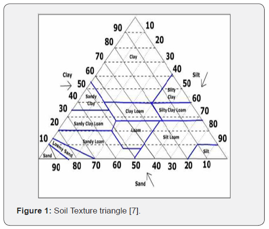
obtained from the soil taxonomy map. For each of the soil textural
classes, the mean percentage of silt, clay and sand can be derived
from the texture triangle, and these values can be used to calculate
the geometric mean particle diameter (mm) as recorded by Shirazi
& Boersma [7].
The information required for the determination of the K factor
can be obtained from the soil taxonomy map. At the basin scale,
soil reconnaissance survey can provide information required for
generation of composite maps of soil mapping units that can be
used for the determination of K values. For each of the soil textural
classes, the mean percentage of silt, clay and sand can be derived
from the texture triangle (Figure 1). These values can be used to
calculate the geometric mean particle diameter Dg [mm]. Shirazi
and Boersma [7] used the proportions of clay, silt and sand to obtain
the geometric mean of particle diameter Dg[mm] and its geometric
standard deviation (σ).

Soil texture triangle is used to classify the texture class of a
soil. Sides of the triangle are scaled for the percentages of sand,
silt, and clay. Clay percentages are read from left to right across the
triangle (dashed lines). Silt is read from the upper right to lower
left (light, dotted lines). Sand from lower right towards the upper
left portion of the triangle (bold, solid lines). Boundaries of the
soil texture classes are highlighted in blue. The intersection of the
three sizes on the triangle gives the texture class. For instance,
consider a soil with 20% clay, 60% silt, and 20% sand it falls in
the “silt loam” class. As argued by Wischmeier et al. [4], when data
on soil permeability, structure, and organic matter are available,
Equation 3 can be applied to determine K- factor.

Where,
M-[%very fine sand+%silt]×[100- %clay]
OM-Percentage of organic matter
S-Code according to the soil structure (very fine granular=1,
fine granular=2, coarse granular=3, lattice/massive=4), and
P-Code according to the permeability/drainage class (fast=1,
fast to moderately fast=2, moderately fast=3, moderately fast to
slow=4, slow=5, very slow=6)
Methodology
Basic data to estimate the erodibility (K) factor values and
soil hydrological parameters (texture, hydraulic conductivity, soil
moisture, soil depth) were obtained from the soil map for river
Nzoia basin. The soil map was obtained from FAO (http://www.
fao.org) i.e. Kenya Soil and Terrain (KENSOTER) database. The soil
map shape file was added as a layer into ArcGIS 10.1 and its attribute
table edited with additional new field of K values generating
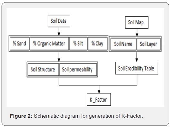
K-Factors for various soil layers. Figure 2 shows the schematic diagram
used to generate the soil erodibility (K) factor.

Result and Discussion
Soil erodibility K value map was generated to show spatial distribution
of erodibility (Figure 3). The study revealed that K-factor
value range was 0.00 to 0.31ton ha-1MJ-1mm-1.

The erodibility factor was classified into: Low (0-0.09); Moderate
(0.09-0.13); High (0.13-0.19) and Severe (0.19-0.31) levels.
Areas spanning Soy, Leseru, Eldoret, Kaptalelia, Kitale, Ainabukoi
and Cherenganyi with erodibility factor between 0.0 and 0.13 are
at a low to moderate soil erosion risk. These areasare mainly characterized
by heavy vegetation cover. Regions covering, Khachonge,
Kipkaren, Sang’alo, Mumias, Buhuyi had erodibility (K) factor
(0.19-0.31) that reflects severe predicted soil losses due to water
erosion.The high values of K-Factor could be as a result of the highly
silty nature of the soils from the affected areas. Silty soils lack
cohesion as their particles are loose therefore require little drag
force to be transported by the force of moving water.
Most erodible soils are silts and fine grain sands. High erodibility
of silty soils is due to small size and weight of the grains and
to their low cohesion. As a consequence, sandy and silty grains are
easily detached and transported by overland flow. In addition, anthropogenic
activities, mainly agricultural, pre-dispose these areas
to high soil erosion risk. The low erodibility factor value could
be attributed to the more clay content present in the soils in most
parts of the basin. They provide higher binding and inter binding
forces that increases cohesion of soil particles. As well, there is the
presence of land cover which helps in resisting detachability of the
soil by water.
Conclusion
Soil erodibility factor (K) in the Revised Universal Soil Loss
Equation (RUSLE) significantly correlates with soil loss. It is a
fundamental factor in soil erosion hazard modeling and prediction.
In this study, soil erodibility (K) factor was classified into: Low;
Moderate; High and Severe levels. Its range was between 0.00
and 0.305ton ha-1MJ-1mm-1. Mean factor was estimated to be
0.13ton ha-1MJ-1mm-1. The upper river Nzoia basin has a low soil
erodibility factor (K) ranging from 0 to 0.13ton ha-1MJ-1mm-1.
This was attributed to the land cover that is majorly forestland.
Area spanning middle up to the lower basin has a high K-factor
with a range of 0.13 to 0.305ton ha-1MJ-1mm-1. The high K-factor
is associated to the land use that is primarily characterized by
agricultural activities that tend to leave the soil surface bare. This
area is likely to experience high soil erosion due to rainfall and
surface runoff. Therefore, it is in priority for soil conservation
programmes.
For more articles in Open Access Journal of
Engineering Technology please click on:


Comments
Post a Comment