The Usability of ALOS-30m DEM for Flood Inundation Mapping in Data Sparse Regions: Sojasrood, Iran - Juniper Publishers
Juniper Publishers - Open Access Journal of Engineering Technology
Abstract
The accuracy and quality of topographic datasets play
an important role in deriving terrain model that is required for
hydraulic simulation. Despite of several studies that have been carried
out over the past decades it is still remained as a challenging issue
for researchers, especially in developing countries and data limited
areas. This study addresses the usability and efficiency of one of the
newest remote sensing based DEMs, called ALOS-30m DEM, for flood
inundation mapping in SojasRood river. Findings, indicate that the
ALOS-30m dataset accurately captures the topographic details of river
bed and the shape of cross-sections as well as topographic maps and this
means that this valuable data source, in spite of having low
resolution, have an appropriate potential of replacing the ground based
DEMs. Moreover, assessing the predicted flood's components illustrate
that using ALOS-30m dataset produces more accurate results when compared
to contour based DEM. For instance, the maximum relative error in
simulating mean WSE and inundated extent based on this dataset is lower
than 13 % and 8%, respectively.
Keywords: Ground based DEM; ALOS-30m DEM; Flood inundation mapping; Remote sensingIntroduction
Hydraulic models are the best tools for simulation
of flood and they provide predictions of flood extent and depth that are
used in the development of spatially accurate hazard maps. In order to
decrease the flood damages in rivers, identifying high flood risk areas
by using these types of models is so necessary Flood inundation mapping
involves analysis of river flow data, hydrologic/hydraulic modelling and
topographic surveys [1].
In flood inundation mapping studies, water surface elevation and flood
extents play an important roles, especially in estimation of flood
damages [2,3].
One of the most important variables that affects the accuracy of
hydraulic models' outputs is the quantity and quality of topographic
datasets or DEMs [1,4-7].
There are several studies that have been carried out
to investigate the effects of DEM resolution and different topographic
datasets on the performance of hydraulic models. For example, Werner et
al. [8]
analyzed the effect of DEM resolution on the accuracy of simulated
flood areas and found that using coarser resolution DEM decrease the
accuracy of hydraulic controls’ elevations and flood extents, while
using finer resolution DEM increase the computational time
significantly. Haile et al. [9]
investigated the sensitivity of 2D SOBEK flood model to DEM resolution
(from 1m to 15m) for an urban area in Honduras. Results showed that,
because of averaging of small scale topographic features, DEM with the
largest cell size simulated maximum inundated area. Casas et al. [10]
Assessed the accuracy of different topographic sources in 1D hydraulic
modeling for Ter River, Girona in NE Spain and concluded that the
contour based dataset resulted the least accuracy in simulated flood
areas, while LiDAR and GPS based datasets performed with the highest
accuracy with less than 1 and 8 % variation, respectively. Sanders et
al. [11]
Simulated flood extents in Santa Clara River in Texas by using four
different DEM sources and showed that LiDAR DEMs, due to having the
highest horizontal and vertical accuracy, are the best sources of
terrain modeling and subsequently flood simulation. Schumann et al. [12]
Demonstrated the effects of three DEMs at three different resolution
from different data sources on deriving the water surface elevation and
inundation area that simulated by using HEC-RAS 1D model. Findings
indicated that although LiDAR and contour based DEMs resulted the lowest
RMSE in deriving water surface elevation, but considering the
performance of the SRTM DEM showed that this data set, despite of having
coarser resolution, is a valuable source for flood simulation
especially in large and homogenous areas. Patro et al. [13]
selected an area in India to investigate the application of SRTM DEM
with 90 meter resolution for extracting cross sections and hydraulic
modelling. Findings revealed that the performance of hydraulic model was
quite well, especially in simulating the peak flood value. Tarekegn et
al. [14]
evaluated the usefulness of ASTER DEM for flood simulation in a river
in Ethiopia and concluded that the simulated flood inundated areas were
in a good agreement with the observed flooding pattern. Azizian and
Shokoohi [15,16]
addressed the effects of different DEM resampling methods on
topographic index and the performance of TOPMODEL in Azarood river basin
and found that Universal Kriging (UK) and Topo2Raster (T2R) methods are
the best in simulating hydrograph peak flood. Ali et al. [3]
assessed the impact of different DEM sources (SRTM, ASTER and LIDAR) on
1D hydraulic modeling of floods on a reach of the Johor River, in
Malaysia. The outcomes showed that the loss of model accuracy due to
resampling the fine resolution DEM to coarse resolution is much less
than that of due to the use of low cost and low quality DEM.
In data sparse regions or developing countries,
accessing to high resolution DEMs, such as LiDAR DEMs, isn't possible
and ground based topographic maps should be provided. Moreover, the
costs of ground surveying is one of the most limiting factor, especially
in projects that suffer underfunding problems. Therefore, there must be
an alternative topographic datasets for tackling or mitigating this
problem. With the significant increase in human's technologies, the
quality of remote sensing based DEMs is growing up so fast every day.
One of the newest DEM sources is ALOS-30m resolution DEM that has been
provided by the Japan Aerospace Exploration Agency (JAXA). Reviewing the
literatures shows that there is no specific studies about the
applicability and efficiency of this dataset for flood inundation
mapping. So, the main objective of this study is to evaluate the
performance and applicability of ALOS-30m DEM, free-public domain
dataset, in flood inundation mapping and hydraulic simulation.
Methods and Materials
Methodology
To accomplish the objective mentioned earlier, the methodology includes the following steps:
1) providing ground based topographic map with the scale of 1:1000;
2) create DEM with 30 meter resolution;
3) collecting ALOS DEM with spatial resolution of 30 meter;
4) flood simulation and inundation mapping using 1D HEC-RAS and HEC-GeoRAS;
5) comparing the hydraulic features (flood extent and water surface elevation) that obtained from using both DEMs.
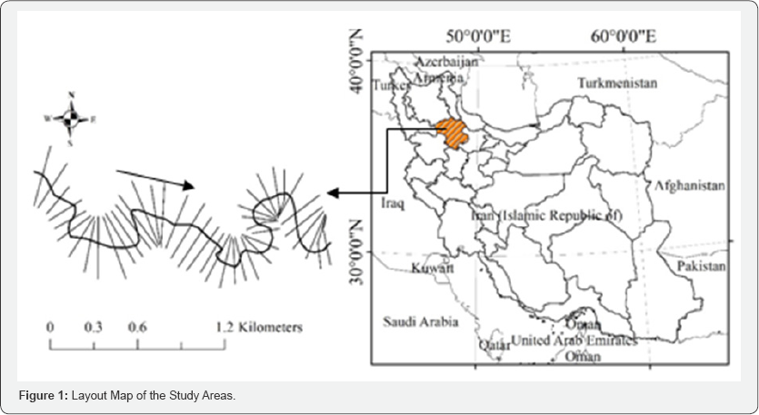
Study area The case study which is used in this research is SojasRood river, Zanjan province, Iran ( Figure 1).
The SojasRood River is located near the Gheidar city, and is surrounded
by Agh- Dagh mountainous and agricultural areas. The main channel of
this river is V-shaped and surrounded by small trees and natural
vegetation, which affect the flow moving between floodplain and main
channel. Flood simulation for this river is performed by using 100-year
flow for steady state. The main reason that leads to selection of this
return period is the flood inundation conditions in the large study
reaches. Because in this reaches the floodplains do not get inundated
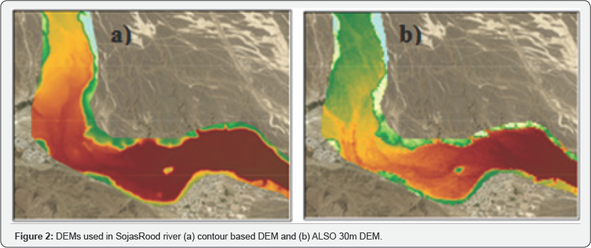
for smaller return period flows. The quality of 30 meter DEM resolution
that obtained using both ground based dataset and ALOS source, is shown
in Figure 2.
Results
The accuracy of ALOS-30m DEM in deriving crosssections
Comparing the terrain model obtained from ground
based DEM, as a base model, and ALOS-30m DEM shows that there is a good
agreement between them. Accurately presenting the topographic features
of river bed is one the most important factors that increases the
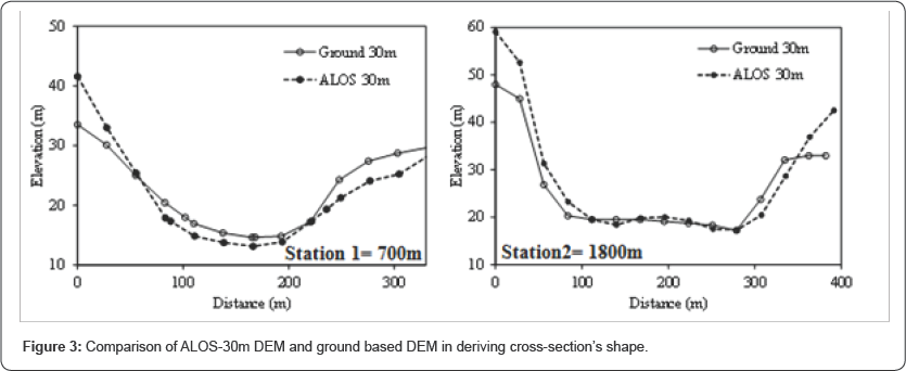
similarity between this dataset and ground based DEM. The efficiency of
this DEM source in deriving the shape of cross-section versus ground
based DEM is shown in Figure 3.
As it can be clearly seen, ALOS-30m DEM accurately capture the shape of
cross-sections and river bed elevations as well as topographic map. In
other words, ALOS-30m DEM is an appropriate alternative for ground based
DEMs, especially in data limited regions [17-26].
Efficiency of ALOS-30m DEM for hydraulic simulation
Findings on flood simulation reveal that hydraulic
modeling and flood inundation mapping using ALOS-30m dataset produces
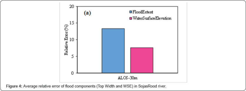
more accurate results when compared to ground-based DEM. For example,
using this dataset in SojasRood river results averagely 13.4% and 7.6%
relative errors in simulating inundated extent and water surface
elevation (WSE) (Figure 4).
Results show that by using ALOS-30m DEM the relative error of inundated
extent in 90% of cross-sections is lower than 15%. In addition, if the
value of ±10% is used as a reasonable relative error range, the
performance of HEC-RAS model in more than 78% of crosssections obtained
from ALOS-30 will be acceptable.
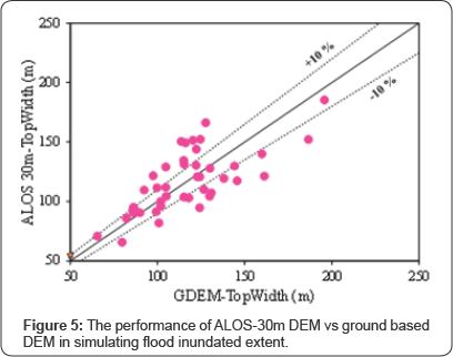
Finally, for better assessing the performance of
ALOS-30m DEM in flood simulation, the results of hydraulic simulation in
each cross-section compared with that of in ground based DEM with 30
meter resolution's result (Figure 5).
As mentioned, in this research the error band width of ±10% in
simulating inundated extent accepted as a reasonable range for
evaluating the usability of ALOS-30m DEM. The results clearly prove that
using ALOS-30m DEM leads to better performance almost in most
cross-sections and can be considered as the best alternative for
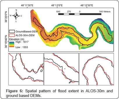
topographic maps Moreover, the spatial pattern of inundated extent in
SojasRood river (Figure 6) completely prove the advantages of ALOS-30m DEM.
Conclusion
The accuracy and quality of topographic datasets play
an important role in deriving terrain model that are required for
hydraulic simulation. Despite of several studies that have been carried
out over the past decades it is still remained as a challenging issue
for researchers, especially in developing countries and data limited
areas. This study addresses the usability and efficiency of one of the
newest remote sensing based DEMs, called ALOS-30m DEM, for flood
inundation mapping in SojasRood River. Findings indicate that the ALOS-
30m dataset accurately captures the topographic details of river bed and
the shape of cross-sections as well as topographic maps and this means
that this valuable data source, in spite of having low resolution, have
an appropriate potential of replacing the ground based DEMs. Moreover,
assessing the predicted flood’s components illustrate that using
ALOS-30m dataset produces more accurate results when compared to contour
based DEM. For instance, the maximum relative error in simulating mean
WSE and inundated extent based on this dataset is lower than 13 % and
8%, respectively.
For more articles in Open Access Journal of
Engineering Technology please click on:


Comments
Post a Comment