Altitudes Effects in Calibration of Ground Doppler Radar for Rainfall Estimation - Juniper Publishers
Juniper Publishers - Open Access Journal of Engineering Technology
Abstract
Unipolar ground-based weather radar has been a
widely-used instrument for rainfall measurement. These radar
measurements however need to be calibrated for more accurate rainfall
estimation. This article introduces a new calibration approach using
time-stepwise processing of reflectivity-rainfall rate (Z-R)
relationship. Based on previous work utilizing the radar-rainfall
relationship; this article hypothesizes that the rainfall measurement
from ground based radar are affected by distance from radar, altitudes
and rainfall time duration. Two consecutive years unipolar ground-based
radar data sets with 77 occurrences of rainfall from 39 stations in
calibration window of three hours; and the corresponding rainfall
measured from registered rain gauges were used in this study. The
results indicated that radar-rainfall relationship Z=aRb is better
improvise with altitudes effect (H) and empirical coefficient (c), such
that (Z=aRbHc). The changes in ‘distance from the radar’ and ‘duration
of precipitation’ were evidently significant. For radar-rainfall
relationship individually (R2=min88, max97) with altitude effect (H) in
relationship (R2=min70, max97). It is therefore concluded that the use
of other effective parameters (distance from radar, altitudes and
rainfall time duration) leads to optimum accuracy of Z-R relationship.
Keywords: Radar-rainfall; Relationship; Calibration; AltitudesAbbrevations: RHI: Range Height Indicator; PPI: Plan Position Indicator; CAPPI: Constant Altitude Plan Position Indicator; IMO: Iran Meteorological Organization; dB: Decibel
Introduction
RHI: Range Height Indicator; PPI: Plan Position
Indicator; CAPPI: Constant Altitude Plan Position Indicator; IMO: Iran
Meteorological Organization; dB: Decibel
In this paper, we investigate the effects and
properties of the altitude and rainfall time duration in radar-rain
gauges relationship in order to ground-based radar calibration. Since
1948, after Second World War, weather ground-based radars are predicting
rainfalls based on Marshal-palmer proposed relationship [6]. According
to this universal relationship, there is a strong correlation between
the rate of the radar reflectivity (Z) (dB) and the rainfall amount (R)
(mm/h) that is known the Z-R relationship. Return signal from atmosphere
targets are dimensionless information and called dimensionless radar
output (DRO). The DRO value is the 8bit alteration of audio-visual
motion that ranges between 0-255 dimension integers [3]. However, there
are a strong relationship between Z and R in Z=AR^(b ) equation this
does not mean that reflectivity from radar is exactly equal to the
amount of rainfall [7,8]. The A and b are empirical coefficients which
refer to climatological characters, location of rainfall, rainfall
seasons, geographic latitudes [9] and rainfall time duration [10]. The
empirical coefficients depend
on climate characteristic in each area exclusively [11]. A lot of
researches have been done to determinate Z-R relationships and
relevant regional coefficient [12]. More than 100 relationships
are available for different rainfall form such as strait form,
tropical, convective, thunderstorm, shower, monsoon and
hurricanes [7]. The sensitivity variation of Z–R relationships
are the main uncertainty sources [13], especially in rainfall
calculation based on DSD. Because of radar measurements carry
many uncertainty sources depending on dissimilarities of radar
reflectivity in the atmosphere; Radar calibration is unavoidable
to estimate the amount of rainfall precisely [14]. Consequently
the values of A and b coefficient is fluctuating from place to place,
season-to-season, and time to time.
As, most of the improbability occur more far from the radar,
distance from the radar is a main factor in all of uncertainty
sources [15]. Most errors are found away from the radar [16].
This means that majority uncertainty is related to dimension
from the radar [17]. Distance (d) between overshooting
reflectivity (radar station) and the location of drop raining (DSD)
is very important parameters to ground-based radar calibration.
Previous studies have shown that this calibration can further
improved radar-rainfall estimation by use of multiple Z-R
relationship [18], rainfall types [19], distance from the radar [20]
and other parameters [21]. These parameters are discussable
in different weather situation in all rain’s types at duration of
different seasons.
In addition to the above calibration, this study also
hypothesize a new improvement of the universal relationship
taking in to account the effects of altitude (H) and distance from
radar (D) and other new coefficient such as (c). Thus producing
new improve algorithm for the relationship such that Z=AR^(b)
H^(c). The radar zones are defined in circular shape from
the center of radar station. The effects of distance in rainfall
estimation are investigated in 0-50km (zone 1), 50-100km (zone
2), 100-150km (zone 3) and 150-200km (zone 4) far from the radar. Also this paper uses the hourly rainfall products from
registered rain gauges.
Radar Rainfall-Relationship
It is assumed that raindrop shapes are spherical and sizes are
smaller than the radar wavelength. There are special equations
between reflectivity and the characteristics of rain drops. It is
important to qualify radar reflectivity (Z) because the reflectivity
depends on the number and diameter of raindrops on the radar
sample volume [22]. The reflectivity (Z) is dependent of number,
diameter and velocity of rain drops;


Where Z(mm6 / m3 ) is reflectivity, R(mm / h) is the rainfall
rate, N (D)dD is the mean sum of raindrops, D(dD)(mm) / m3
of air (Ni is the number of drops with Di the diameter of the ith
element), and Vt (cm/second) is the droplet terminal velocity.
If the above equation (1,2) with respect to the similarity
parameters equivalent to each other, the equation (3) will be;

This means there are strong relationships between
reflectivity and the amount of rainfall. According to this strong
relationship, the A and b coefficient has been found consequence
of improve the equation (3);

It is assumed that height differences (altitude) are more
effective parameter in radar-rainfall estimation.

Here this paper tries to improve equation (4) and corroborate
equation (5).
Unipolar Ground Based Radar
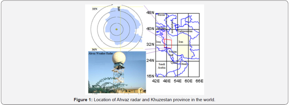
Unipolar ground based radar in Ahvaz, Iran (latitude: 31˚20’,
longitude: 48˚40’ and 152m height) is use in this study. Figure
1 shows the location and configuration of Ahvaz’s radar station
with the zones of data acquisition. The area of coverage by this
radar footprint is between 29˚55’ until 32˚30’ in semi-arid zone
at northern hemisphere. Ahvaz is a S-band radar which is located
close the Ahvaz city in 31˚20’N with 7.5cm wavelength and 2GHZ
that is serviced by 750 kilowatt transmitter power. The radar
transmitter is of TXS 1500 model that includes a modulator
with an active klystron tube-produce and amplifies microwave
pulse. The antenna diameter and Radom diameters are 8.5m
and 11.65m, respectively. The Doppler range is 200km and non-
Doppler range is 400km; spatial resolution is 1x1km. Details
about technical specifications are shown in Table 1. The station
has the capability of producing the range height indicator (RHI),
plan position indicator (PPI), constant altitude plan position
indicator (CAPPI) and SRI.
This study, however, only used plan position indicator
(PPI). The entire Ahvaz radar station is managed by Iran
Meteorological Organization (IMO) and is under the jurisdiction
of national weather radar network. The main radar data acquire
reflectivity numerical amount per decibel (dB) unit. These data
are processed using the RAINBOW software to convert radar
reflectivity into dB unit. The rainfalls are typically in reflectivity
range between 5-75dB; light rain begins at 5dB and hails at
80. To investigate changes due to different distances between
reflectivity and rainfall location data were recorded from four
zones surrounding the radar station (Figure 1).
Algorithm Process
The basic background of this theory for this study is that,
for each altitude can estimate one Z-R relationship. Also Z-R
relationship changes are considerable in each step time of rainfall
time duration. Accordingly, it is designed two algorithms based
on multiple regressions. In first step, the algorithm starts whit
simple mode; relationship between one independent variable
and one dependent variable. Rainfall (mm/h) in all equation is
independent variable and radar reflectivity (dB) is dependent
variable. Variable is arranged based time hourly. According to
the general relationship (marshal- palmer), the equation is;

This relationship is extended for all station that is collection
in 3 three hours of rainfall and four zones surrounding radar.

Where, Z is radar reflectivity, R is rainfall amount, ti is rainfall
time duration, 1th-2th-3th hours of rainfall; here is investigated 3
time of rainfall from rainfall start until 3th time of rainfall based
hourly. The j Z introduce four zones; zone1 (0-50km), zone2
(50-100km), zone3 (100-150km), zone4 (150-200km). The
coefficient i a and i b are the empirical coefficients and tiZj e are
partial errors in each zone and each time. Taking into account, all
of the data in a coordinate system, we can to reach equation (8);

The (t) is mean; using all data in the entire region of rainfall
in one coordinates.
Second algorithm tries to find new matrix mode of data with
effects of altitude differences. This parameter for first time is
used in this paper. When the factor H is considered in the second
algorithm, the coefficient (c) is generated. (c) Coefficient is a
novel empirical coefficient that is dependent of geomorphology
rainfall location. Here after, (c) coefficient is called “altitude
coefficient”. The new algorithm is introduced in equation (9);
such that;

This algorithm is experimented in 3 hours of rainfall
occurrences in 4 defined zones center about Ahvaz radar station.

Equation (10) parameters are exactly same equation (7),
the only difference is n H . The n H show altitude changes at each
point where the rainfall is measured. Taking into account, all of
the data in a coordinate system, t; is the total of data. As a result,
we can to reach equation (11);

As a result, equation (11) presents the relationship between
reflectivity and all parameters and coefficients in all data in all
places and all times of precipitation. However, previous studies have determined the relationship between reflectivity and
rainfall amount based on power regression [3,4,10,13,18,23-
28]. But, it is possible that the relationship be manifested in
other matrix form such as; linear, logarithmic or exponential
regression. Here, according to Marshall-palmer first used
power regression in all parameters of research. In this paper, in
order to measure distances and geographic location control is
used ArcGIS 9.3 software. It is used 2011b version of MATLAB
software to mathematics and technical computing.
Results
There are strong relationship between radar reflectivity and
rainfall amount in semi-arid zone in the middle latitudes and
relevant coefficient. Z-R relationship is investigated in all zones
and 3 time of rainfall time duration (Table 2).
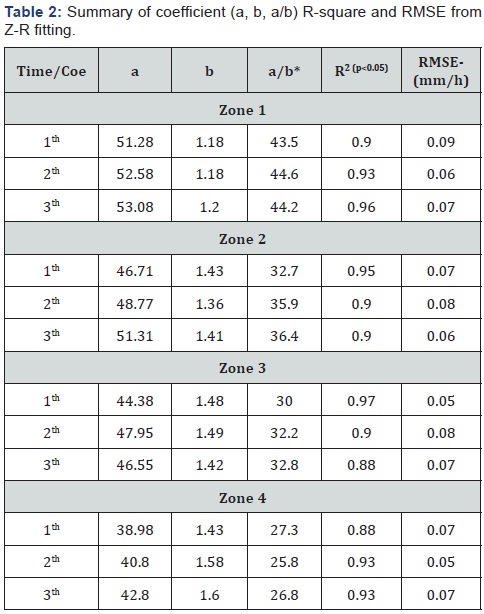
Table 3 shows the amount of empirical coefficient (a, b)
and relationship between variables in 4 zones and 3 times of
rainfall. There are no significant differences between value
obtained and other research in middle geographic latitudes. We
found the range of coefficients of variation; (38.98
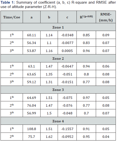
Exploration the relationship among altitudes (H), radar reflectivity (Z) and rainfall amount (R); Z-R-H
According to equation (11), Z = aRbHc + e has been
proven, there are strong relationship between Z-R-H. In the
new hypothesized relationship, upon entering H parameter,
the c coefficient is generated. The c coefficient changes show
the condition and characteristic of altitude parameter. Figure
3 schematically shows the general shape of the Z-R-H genesis,
as discussed in this article. The value of this new empirical
coefficient is a negative numeric, which infers that reflectivity
(Z) with altitude (H) have inversely proportional relationship.
Also, at higher elevations, much less radar reflectivity is noted.
This can be interpreted based on the convective precipitation at
height. The Z-R-H relationship is investigated in all zones and 3
time of rainfall time duration.
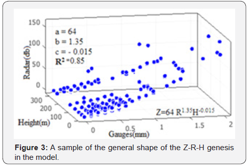
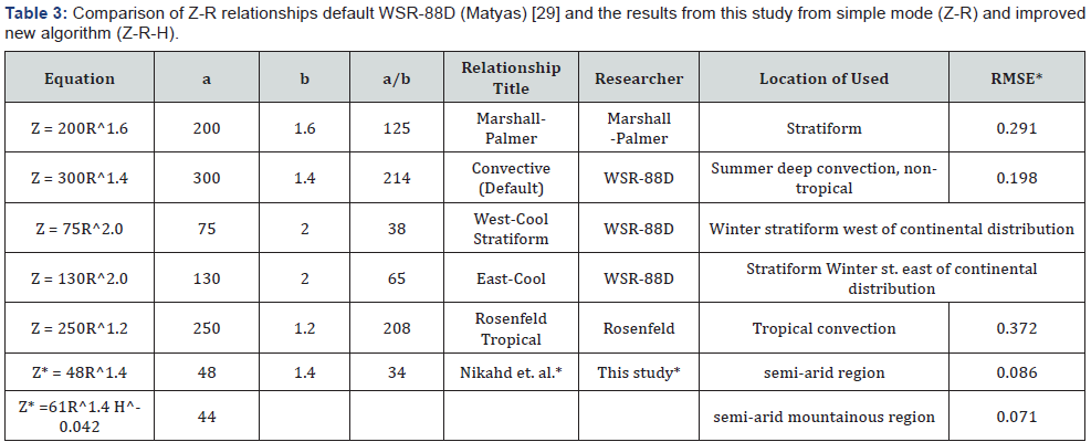
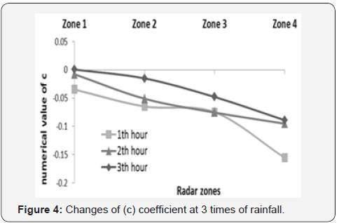
Table 3 shows the value of coefficient c with respect
to
other related parameters in all locations (zones) far from the
radar station. We found that coefficient c varies within range
of (0.0005) to (- 0.0952), with significant changes in distant
zones. It is clearly evident that the amount of reflectivity is less
in distant zones. But in terms of the third zone is different due to the
mountainous conditions. It can be explained and justified.
This result is not unexpected. Figures 4 & 5 are shown the
amount of new empirical coefficient and relationship between 3
variables in 4 zones and 3th times of rainfall.

In summary it can be said; Z-R relationship at different
heights, various distances from the radar station, even when
rainfall begins moment to end rainfall is very changeable. Based
on this theory that others parameters are effective and can be
entered in the Z-R equation.
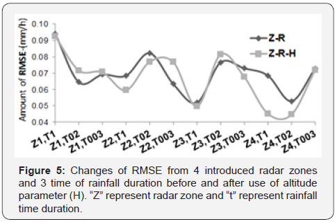
Therefore, the altitude parameter (H) was entered and
confirmed through this study. Changes of RMSE, in simple mode
(Z-R) and when use altitude parameter (Z-R-H) show that new
improved algorithm has better fitting. Figure 5 demonstrate
changes of RMSE from 4 introduced radar zones and 3 time of
rainfall duration before and after use of altitude parameter (H).
Amount of RMSE in new mode (Z-R-H) at 4 zones of radar and 3
times of rainfall is lower than before use of altitude parameter
in equation. Figure 6 is fitting the previous equations (Marshall-
Palmer, Rosenfeld and WSR 88) and our research with and without altitude parameter. Amount of RMSE confirm that
the new Z-R-H equation is able to replace with universal Z-R
equation (Table 3).
Discussion
Using the Z-R-H methodology for unipolar ground-based
radar calibration and vagueness estimation provides beneficial
and valuable outcomes. This equation is applied on the radar
calibration, which suit precisely for unipolar ground-based
radar type. The results of this study clearly illustrate that the
agreement between radar reflectivity and rainfall amount is
highly dependent on altitudes effects. Table 3 summarizes the
comparison of Z-R relationship obtained with similar previous
studies. The value of empirical coefficients from different areas
is presented. This study noted Z-R relationship in semi-arid
region, where the coefficients are unique. Also, considering
that the other parameters have been ignored in radar rainfall
estimation, this study has focused on three effective parameters
in radar rainfall equation: altitudes effects, distance from radar
and rainfall duration.
Accordingly, to investigate the effectiveness of distance
from radar, areal coverage was divided into 4 zones. To
determine impact of altitudes, altitude for all rain gauges was
interfered in the equation. The first three hours of rainfall was
considered in order to enable detection of changes in rainfall in
initial precipitation and subsequent periods. Such results are
commonly used for meteorology and hydrological applications;
hence, this is beneficial and particularly important to similar
regions of study.
This paper noted strong relationship (R2min=83) between
radar reflectivity and the amount of rainfall (Z-R), in the semiarid
zone in geographic middle latitude of northern hemisphere.
Empirical coefficient (a,b) changes presented relevant correlation
in different situation and location far from the radar source. They
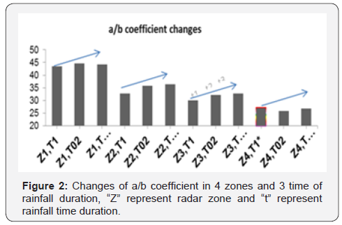
are strongly dependent. The new a/b coefficient expressed the
changes empirical coefficient far from the radar. As it is distant
away from the radar station, a/b coefficient decreases, indicating
that radar echoes are less returning to receiver from far radar
stations. This result is not unexpected, because the uncertainty
resources have a large impact on the amount reflectivity. It is
evident that all the empirical coefficients do not change with
different time of rainfall. Nonetheless, there is no considerable
a/b coefficient changes in first to third time of rainfall
occurrence. Evidently, there are minor changes, but cannot be
fully interpreted at this point time as they do not follow a logical
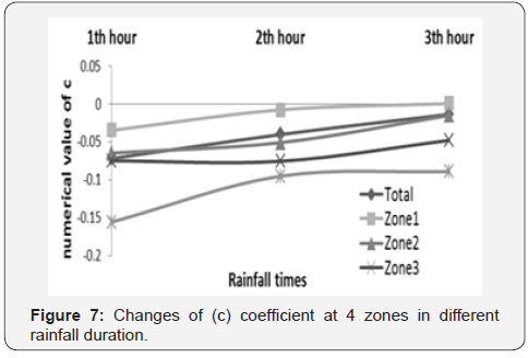
sequence (Figure 4 & 7). The benefit of the a/b is obvious, since
the changes of amount of rainfall changes with corresponding
radar reflectivity in far from the radar (distance) and duration
of rainfall time. Hereafter, in order to allow for very fine radar
adjustment it is therefore better to use a/b coefficient instead of
(a) and (b) coefficients separately. This fine adjustment is very
sensitive in case like calibrating of Z-R relationship for urban
areas for flood control that needs more caution. New coefficient
a/b has the ability to show characteristic of region better than
last empirical coefficients. It can be a strong default for ground
based radar in different geographic latitude prior to anticipated
operations.
The altitudes parameters entry in radar equation is the
first attempt in this study and this is very crucial in this field of
study. Given that the others parameters in the Z-R relationship
can be effective, altitude (H) parameter is entered and for first
time Z-R-H is defined. In the new hypothesized relationship,
upon entering H parameter, the coefficient c is generated. The
coefficients changes show the condition and characteristic of
altitude parameter. Figure 6 shows an overall trend of the Z-R-H,
as discussed in this article. Although the case study (Khuzestan
province) is a relative flat area and parameter H with coefficient c
changes are explainable in different location and times. Figure 6
is fitting the previous equations (Marshall-Palmer, Rosenfeld and
WSR 88) and our research with and without altitude parameter.
A change in c shows the effect of rainfall types (mountainous and
conventional) in radar equation. Maximum value of R-square
98 in different time and different location shows there are
strong relationships between 3 parameters, namely, the Z-R-H.
The coefficient c changes ranges 0.0005 to-0.0952. We noted c
coefficients are negative values, except highest value in the first
zone at 3rd times of rainfall. These negative values in power of
altitude parameter (H) display that at higher altitudes the return
echo (Z) is lower than flat areas, and this is agreeable to amount
of precipitation at higher altitudes is more than plain. These
results can interpret amount of mountainous precipitation
in radar-rainfall equation. An inevitable consequence of the
relationship is that the H parameter and c coefficient would be
the main part of radar-rainfall equation (Z-R) for future users
in hydrometeorology. The ultimate amount of Z-R-H relationship
for semi-arid zone is obtained and is given in Table 3.
The results of this study also well indicated that coefficient c
alternate from first time of rainfall to other next times. So we can
say that, when more time of precipitation passes the value of (c)
coefficient is greater. We interpreted this is due to the “increase
influence of convective phenomena”. Obviously, the level of this
claim is a discussable theory. Notable issue is that, there is no a/b
coefficient changes in duration of rainfall times but coefficient c varies considerably. The new relationship is very useful in
watershed hydrology management because the duration of
precipitation and distance from the location of the precipitation
from basin outlet is very important especially in flood routing
and flash flood control. Although, the authors have considered
the new relationship in order to allow radar calibration, it is
not doubtful that any improvement by using other effective
parameters will be highly rational.
For more articles in Open Access Journal of
Engineering Technology please click on:


Comments
Post a Comment